Appley Bridge Gathurst Circular

Circular walk starting from Appley Bridge ascending towards Ashurst Beacon before descending over Dean Brook to Gathust and via Leeds Liverpool canal back to start.

Technical sheet

15516496
A Wrightington walk posted on 04/10/21 by gfl57. Last update : 01/08/23
  • Walking
    Activity: Walking
  • ↔
    Distance: 10.40 km
  • ◔
    Calculated time: 3h 20 
  • ▲
    Difficulty: Moderate

  • ⚐
    Return to departure point: Yes
  • ↗
    Vertical gain: + 117 m
  • ↘
    Vertical drop: - 114 m

  • ▲
    Highest point: 135 m
  • ▼
    Lowest point: 18 m
  • ⚐
    District: Wrightington 
  • ⚑
    Start/End: N 53.577588° / W 2.721657°

  • Today’s forecast: … Loading…
Leeds Liverpool Canal

Description

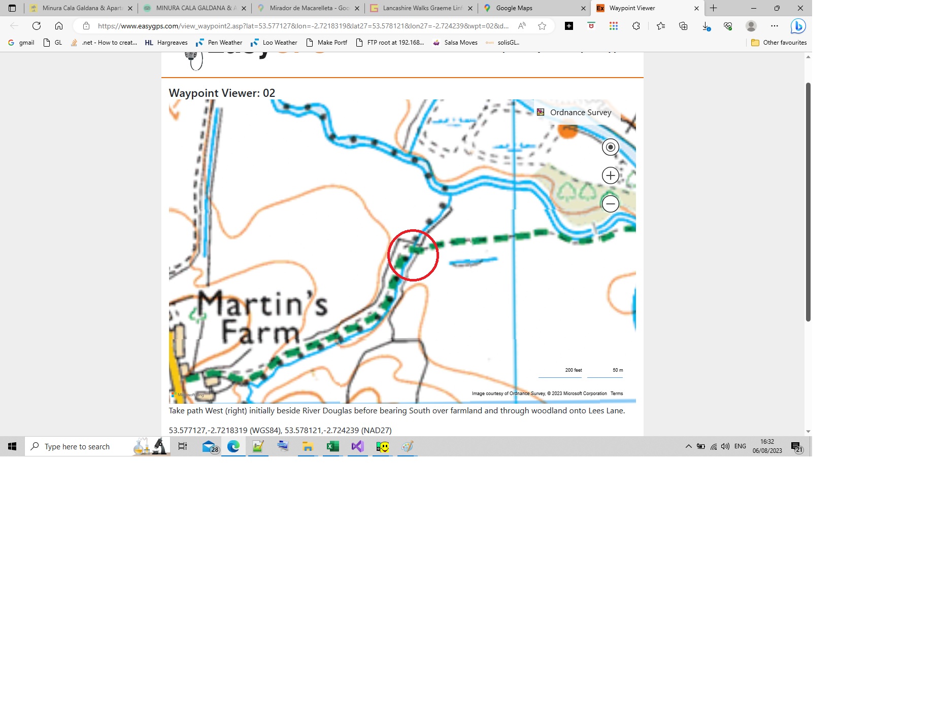
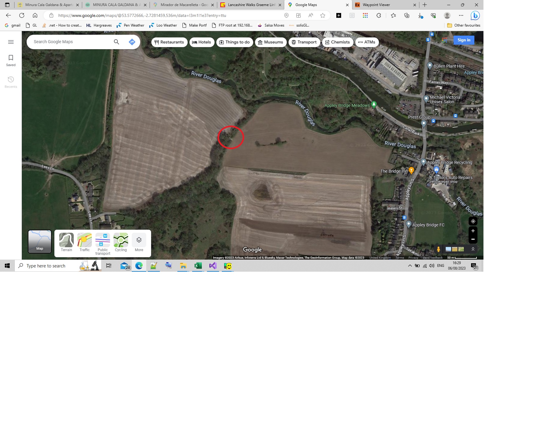
(S/E) Take Appley Lane briefly south over Leeds Liverpool Canal and River Douglas. Take path west (right) initially beside River Douglas before bearing South over farmland and through woodland onto Lees Lane.

(1) Leave Lees Lane taking footpath, no footpath sign, south-west (right) through the gateway and then into woodland. Turn east (left) along Long Heys Lane.

(2) Take Stonehall Lane south-west (right)

(3) Continue on track as it turns south (left) to pass by Stone Hall. Excellent views east over Winter Hill,
Manchester and Pennines. Briefly turn east (left) along Farley Lane.

(4) Leave Farley Lane on the footpath to continue east over the grassland.

(5) Upon reaching Roby Mill Lane, turn north (left). Take footpath east (right) between houses then beside the stream.

(6) Turm north (left) upslope along field boundary Take Ayrefield Drive east (right).

(7) Follow path initially beside duck pond and then east beside field boundary. Cross stile beside the fence and continue on the path as it follows the boundary fence downslope. Take path East (right) as it makes its way down to Dean Brook, take the bridge over Dean Brook to continue on the path under M6. Turn north (left) along Gathurst Road.

(8) Take canal towpath north-west (left). Continue on the towpath. Ascend to Appley Bridge Road.(S/E)

Waypoints

  1. S/E : km 0 - alt. 22 m - Start
  2. 1 : km 1.01 - alt. 32 m - Lees Lane
  3. 2 : km 1.8 - alt. 62 m - Stonehall Lane
  4. 3 : km 2.76 - alt. 128 m - Manchester View
  5. 4 : km 3.54 - alt. 127 m - Delph
  6. 5 : km 4.26 - alt. 93 m - Cemetry
  7. 6 : km 4.77 - alt. 75 m - Gabriel Turn
  8. 7 : km 5.48 - alt. 76 m - Permissive Path
  9. 8 : km 7.44 - alt. 30 m - Canal
  10. S/E : km 10.4 - alt. 22 m - The End

Useful Information

Parking at start.
Refreshments available at Appley Bridge, Bank Top and Gathust Station.
More route info : www.graemelinford.com/walks/appley_bridge.html

Always stay careful and alert while following a route. Visorando and the author of this walk cannot be held responsible in the event of an accident during this route.

Reviews and comments

4 / 5
Based on 2 reviews

Clarity of route description
4 / 5
Clarity of route map
4 / 5
Walk interest
4 / 5
gfl57
gfl57
Fresh air
Fresh air

Hi,

The trees were around Dean Brook approx and the stream was close to Martin's Farm.

Thanks

Delphinium
Delphinium

Hi Fresh air,
Thank you for this feedback. By any chance do you know (more or less) where trees are blocking so we can contact the local authorities ?
Also, where did you have to cross the stream? So we can see with the author if there is any alternatives...
Enjoy your walks

Fresh air
Fresh air

Overall rating : 4 / 5

Date of walk : 30/07/23
Clarity of route description : ★★★★☆ Good
Clarity of route map : ★★★★☆ Good
Walk interest : ★★★★☆ Good

Walk description was good but there were some trees blocking the paths. Also we had to cross a stream and just had to walk through it as nowhere to cross.

It was longer about 7.5 miles

Fresh air
Fresh air

Overall rating : 4 / 5

Date of walk : 30/07/23
Clarity of route description : ★★★★☆ Good
Clarity of route map : ★★★★☆ Good
Walk interest : ★★★★☆ Good

Walk description was good but there were some trees blocking the paths. Also we had to cross a stream and just had to walk through it as nowhere to cross.

Other walks in the area

For more walks, use our search engine.

The GPS track and description are the property of the author.

Loading…