Ben A'an Circular Walk, Trossachs

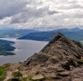
The iconic pointed peak of Ben A’an in the Trossachs is a fantastic wee climb and the views of Loch Katrine and Ben Venue from the top are nothing short of spectacular. With a clear and well-worn footpath all the way to the top, this particular route takes you back down the other side of the hill, through some forest to the banks of Loch Katrine to form a loop.

Technical sheet

26226144
A Stirling walk posted on 30/08/22 by Gillian's Walks. Last update : 31/08/22
  • Walking
    Activity: Walking
  • ↔
    Distance: 6.64 km
  • ◔
    Calculated time: 2h 55 
  • ▲
    Difficulty: Moderate

  • ⚐
    Return to departure point: Yes
  • ↗
    Vertical gain: + 353 m
  • ↘
    Vertical drop: - 348 m

  • ▲
    Highest point: 431 m
  • ▼
    Lowest point: 95 m
View from Ben A'an Summit

Description

(S/E) Exit Ben A'an car park at the main entrance and directly across the road you will see the footpath for Ben A’an heading in a north-east direction.

After an initial steep ascent lasting half a kilometer, the path levels out.

(1) At 265m elevation there is a crossroads - continue ahead (North West) to go across the hillside.

At 290m elevation there is another steep ascent involving a scramble.

(2) The path then circles round to reach the summit of Ben A'an.

(3) Descending via the same initial footpath, after 100m and before you reach the scramble, look out for a lesser-used grassy track on your left. Follow this downhill (North West) towards the forest, enjoying the views of Loch Katrine as you go.

(4) You will reach a stile over a high deer fence. Do not cross. Instead, turn left (West) and walk down the fence-line, keeping the fence on your right-hand side.

(5) After a distance of 900m and an elevation drop of 220m, you will emerge out onto a minor road on the banks of Loch Katrine. Turn left (South) to walk along the road.

(6) After 1.3km you will reach the car park at Trossaschs Pier. Walk through the car park - the road becomes A821/Dukes Pass.

You can either keep to the road all the way to Ben A’an Car Park (1.6km) or you can take a slightly more scenic and longer route (2km).

More scenic/longer route:
Walk along A821/ Dukes Pass for 500m, turning right (South West) onto a minor road known as the Pass of Achray.

(7) Almost immediately turn left (South East) onto a footpath. Follow this mix of earth path and boardwalk for 800m to reach a small car park (300m along there is a fork - you can go either way).

Leave the car park from the main entrance and turn left (NorthEast) onto A821/Dukes Pass, then right (East) at the end of the road. Ben A’an Car Park is 300m along on your right-hand side (S/E)

Waypoints

  1. S/E : km 0 - alt. 99 m - Ben A’an Car Park
  2. 1 : km 1.01 - alt. 266 m - Crossroads
  3. 2 : km 1.88 - alt. 419 m - Ben A'an summit
  4. 3 : km 2.08 - alt. 430 m - Lesser-used grassy path on left
  5. 4 : km 2.4 - alt. 354 m - Stile at deer fence
  6. 5 : km 3.28 - alt. 129 m - Minor road at Loch Katrine
  7. 6 : km 4.55 - alt. 128 m - Trossaschs Pier car park
  8. 7 : km 5.25 - alt. 108 m - Earth and boardwalk footpath
  9. S/E : km 6.64 - alt. 99 m - Ben A’an Car Park

Useful Information

For more information and a walk review, visit Gillian's Walks

Transport
Parking available in Ben A’an Car Park just off A821/Dukes Pass (chargeable)

Terrain
Gravel and earth hill paths, very steep in places with some scrambling required. Also some surfaced roads and boardwalk on the last section.

Always stay careful and alert while following a route. Visorando and the author of this walk cannot be held responsible in the event of an accident during this route.

During the walk or to do/see around

  • Ben A'an summit
  • Loch Achray
  • Loch Katrine (boat trips and water sports)
  • Ben Venue (Munro) - near by
  • Queen Elizabeth Forest Park
  • Duke's Pass forest drive

Other walks in the area

For more walks, use our search engine.

The GPS track and description are the property of the author.

Loading…