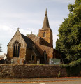
Hoby circular walk

This walk is about 5.5 miles long, starting and ending at the village of Hoby. There are fine views across the undulating Leicestershire countryside from the elevated ground near Ragdale Hall. The route and footpaths are well maintained with visible waymarkers and only a few stiles. Most paths are across crop or pasture fields but note some fields may contain bullocks depending on the time of year.

Technical sheet

1300211
A Hoby with Rotherby walk posted on 21/07/18 by RichardofYork. Last update : 31/08/18
  • Walking
    Activity: Walking
  • ↔
    Distance: 8.83 km
  • ◔
    Calculated time: 2h 40 
  • ▲
    Difficulty: Easy

  • ⚐
    Return to departure point: Yes
  • ↗
    Vertical gain: + 51 m
  • ↘
    Vertical drop: - 58 m

  • ▲
    Highest point: 116 m
  • ▼
    Lowest point: 67 m
Blue Bell Inn
Crop field
All Saints Church, Hoby

Description

(S) The walk starts from the Blue Bell Inn, LE14 3DT in the pretty village of Hoby, Leicestershire. If you plan to have lunch at the pub use the pub carpark. On leaving the pub carpark, turn right up Main Street and follow round until you get to the first Waymarker. This leads onto Ashfordby Road.

(2) Cross Ashfordby Road. At the yellow Waymarker on the opposite north side, enter field and follow several more until you reach the A6006 Loughborough Road, near Shoby village.

(4) Avoid the A6006 road itself by turning left at next Waymarker along a farm track. At the end of the track by-pass the farmyard and head WSW following yellow Waymarkers. Cross stream and continue straight to next Waymarker on right-hand hedge boundary. At this point head WSW away from hedge and across a large crop field until you hit Ragdale Road.There are fine views to the south. At Ragdale Road turn right and follow road into the village Main Street.

At the junction with Six Hills Road, turn left at the Waymarker along a narrow passage heading south and adjacent to a stream.

(7)Turn right and head SW at the next Waymarker across crop fields. Again there are excellent views to the SE. The steeple of Hoby church is visible to the South, as is Ragdale Hall to the North.

(8) Follow the waymarkers going SSE, heading for Hoby. On entering Church Lane, follow the road around pass the church, to the Blue Bell pub. The church is worth a visit. It dates back to 13th Century. The pub won the CAMRA pub of the year award in 2018. The food is excellent.

Waypoints

  1. S/E : km 0 - alt. 76 m - Blue Bell Inn
  2. 1 : km 0.14 - alt. 75 m
  3. 2 : km 0.27 - alt. 75 m - Turn right into Ashfordby Road
  4. 3 : km 0.85 - alt. 67 m
  5. 4 : km 3.06 - alt. 100 m - Turn left on A6006
  6. 5 : km 3.99 - alt. 92 m
  7. 6 : km 4.77 - alt. 110 m
  8. 7 : km 5.44 - alt. 97 m - Turn right and head SW
  9. 8 : km 6.25 - alt. 116 m - Follow waymarkers SSE
  10. 9 : km 7.13 - alt. 80 m
  11. S/E : km 8.83 - alt. 76 m - Blue Bell Inn

Useful Information

Always stay careful and alert while following a route. Visorando and the author of this walk cannot be held responsible in the event of an accident during this route.

Reviews and comments

4.3 / 5
Based on 8 reviews

Clarity of route description
4.3 / 5
Clarity of route map
4.3 / 5
Walk interest
4.3 / 5
Pob27
Pob27

Overall rating : 4 / 5

Date of walk : 01/01/22
Clarity of route description : ★★★★☆ Good
Clarity of route map : ★★★★☆ Good
Walk interest : ★★★★☆ Good

Great walk, took us just over 2 hours. Easy to follow by looking for the yellow waymarkers. Was rather muddy but then it has been raining lots recently

Dog walker
Dog walker

Overall rating : 4 / 5

Date of walk : 26/08/21
Clarity of route description : ★★★★☆ Good
Clarity of route map : ★★★★☆ Good
Walk interest : ★★★★☆ Good

Hard to find the start of the walk but otherwise it was well waymarked. All stiles dog friendly, Not the most exciting scenery but pleasant enough .I thought the distance was longer than that given but that didn't spoil the walk. Easy walk which I will repeat but realise it may not be as easy in wet and muddy weather.
First time I have used the website and was very impressed with the accuracy and detail of the directions,

Novice Walker
Novice Walker

Overall rating : 4.3 / 5

Date of walk : 12/06/21
Clarity of route description : ★★★★☆ Good
Clarity of route map : ★★★★☆ Good
Walk interest : ★★★★★ Very good

Today was a rather hot day. The first Waymarker is Blue which was confusing as the rest were in yellow. Some of the posts in the fields had either fallen over or had the arrow missing so no sure of which direction we were to go. However all in all we made good judgement on the direction to follow except in the middle of one field we came to a t junction path and had no idea whether to go left or right, again good choice made and we ended back at the Blue Bell In PH. Which was very welcoming and great food. The dog was pooped and the cold floor of the pub cooled him down very quickly. Would i walk this route again Yes very enjoyable as long as you don't mind the nettled by the styles.

elaine hall
elaine hall

Overall rating : 4.7 / 5

Date of walk : 27/03/21
Clarity of route description : ★★★★★ Very good
Clarity of route map : ★★★★☆ Good
Walk interest : ★★★★★ Very good

Clear and well defined paths. Lovely views. First couple of fields contained sheep and lambs. All gates were easy to open. Very peaceful. Would walk again.

musicalhamster
musicalhamster

Overall rating : 4 / 5

Date of walk : 06/11/20
Clarity of route description : ★★★★☆ Good
Clarity of route map : ★★★★☆ Good
Walk interest : ★★★★☆ Good

Very pleasant walk. A little bit of up and down but not a lot. Mostly pretty flat, with some lovely views over the fields for quite a long way. An easy to navigate walk, and a nice way to spend a couple of hours.

maria4u
maria4u

Overall rating : 4.7 / 5

Date of walk : 30/05/20
Clarity of route description : ★★★★★ Very good
Clarity of route map : ★★★★★ Very good
Walk interest : ★★★★☆ Good

Slight confusion at the very beginning as the first way marker referred to is a very overgrown bridleway - On the advice of the home owner next door we continued past it and rounded into Ashfordby Road a little further on where the second yellow way marker is obscured behind a steel farm gate on the left.

Lots of up and down hill, through fields of crops, and lots of stinging nettles too. Very peaceful and quiet walk.

I wouldn't say it's an 'easy' walk, not if you have asthma or walking difficulties - more of a 'moderate' walk.

Lovely half day out - will definitely be doing this one again.

mikeayers
mikeayers
• Last modified:

Overall rating : 4 / 5

Date of walk : 31/08/19
Clarity of route description : ★★★★☆ Good
Clarity of route map : ★★★★☆ Good
Walk interest : ★★★★☆ Good

A very pleasant walk with one caveat. The directions are written assuming you have access to a GPS device. Point 8 on the map is in the middle of a large field with the boundaries mostly out of sight. There is nothing on the ground to mark it, and overshooting (as we did) takes you into territory with no waymarks. Ragdale Hall is visible most of the time, but Hoby church, contrary to the description, is not, so there is little to guide you. The lat long of each way point is helpfully listed, but of no use if you don't have GPS.

Despite this, I'd recommend it, and lunch at the Blue Bell was excellent.

Litespeed74
Litespeed74

Overall rating : 4.3 / 5

Date of walk : 17/08/19
Clarity of route description : ★★★★☆ Good
Clarity of route map : ★★★★★ Very good
Walk interest : ★★★★☆ Good

Very nice walk across rural Leicestershire, fairly gentle going with some fantastic views to the South. Would recommend not wearing shorts as some long stretches with stinging nettles and thorny plants. Also be careful of the Bullocks near the farm we, managed to skirt around them but wouldn’t want to walk directly through them as they were very excited and lively. Finished off nicely with a well earned pint in the Blue Bell Inn.

Other walks in the area

For more walks, use our search engine.

The GPS track and description are the property of the author.

Loading…