Loweswater Terrace

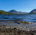
A stunning circular walk with beautiful views over Loweswater and the surrounding fells.

Technical sheet

2627179
A Loweswater walk posted on 04/10/19 by chriswood1954. Last update : 20/11/20
  • Walking
    Activity: Walking
  • ↔
    Distance: 9.22 km
  • ◔
    Calculated time: 3h 15 
  • ▲
    Difficulty: Moderate

  • ⚐
    Return to departure point: Yes
  • ↗
    Vertical gain: + 213 m
  • ↘
    Vertical drop: - 220 m

  • ▲
    Highest point: 321 m
  • ▼
    Lowest point: 123 m
Loweswater 2
Loweswater
The rope swing
Highnook Farm

Description

The walk starts at the sty, just south of Fangs Brow farm, and parking is restricted near the sty at busy times.

(S/E) Take the path across the open field towards the dry stone wall. Stay on this path, following the dry stone wall, up a gentle incline until you come to a gate in the wall, where you turn left onto the lower of the two paths towards Loweswater Terrace.

(1) Continue on the path passing a wooden seat with fantastic views over the lake and surrounding fells. Follow the path around the gully between Burnbank Fell and Carling Knott. Ignore the gate leading into Holme Wood and keep to the path skirting the wood.

(2) Then, the path descends and crosses Highnook Beck before heading onto High Nook Farm. Walk through the farmyard and continue onto Maggie's Bridge.

(3) Do not cross Maggie's Bridge, but take a sharp left and head towards the Lake. The path is clearly defined and leads you towards Watergate Farm. With the farm on your left, walk through the gate into Holme Wood. Continue through the wood along the lake's edge and pass the small cottage in the wood by the edge of the lake.

(4) On leaving the wood, continue along the narrow lane up towards Hudson's Place Farm. Bear right around the back of the farm and take an immediate right through a wooden gate. The path now becomes a bit obscure, but continue climbing through an open field until you come to another wooden gate in the top corner of the field. This lane leads you to passed Jenkinson's Place. Follow the path up the hill, past the weather station, until you come to a dry stone wall and a sty.(S/E)

Waypoints

  1. S/E : km 0 - alt. 220 m - Sty
  2. 1 : km 1.58 - alt. 263 m - Wooden Seat
  3. 2 : km 3.73 - alt. 213 m - Highnook Beck
  4. 3 : km 5.29 - alt. 127 m - Maggie's Bridge
  5. 4 : km 7.4 - alt. 138 m - Exit of Holme Wood
  6. S/E : km 9.22 - alt. 221 m - Sty

Useful Information

Always stay careful and alert while following a route. Visorando and the author of this walk cannot be held responsible in the event of an accident during this route.

Reviews and comments

3 / 5
Based on 1 review

Clarity of route description
1 / 5
Clarity of route map
3 / 5
Walk interest
5 / 5
Gozel
Gozel
• Last modified:

Overall rating : 3 / 5

Date of walk : 02/05/21
Clarity of route description : ★☆☆☆☆ Very disappointing
Clarity of route map : ★★★☆☆ Average
Walk interest : ★★★★★ Very good

The walk directions were not detailed enough at the start, there were points that were very ambiguous and we followed "educated guess" for a little while and finally asked some fellow walkers who luckily knew the walk! Also on the last section it said turn right through a gate, which was possible,but it was clearly the gate on the left!! A lovely walk but you expect your directions to be correct!!!

Other walks in the area

For more walks, use our search engine.

The GPS track and description are the property of the author.

Loading…